Multispectral sensors represent a crucial innovation in archaeology as they allow for indirect soil analysis through the study of the vegetation covering it. Essentially, a multispectral sensor records electromagnetic reflectance, meaning the amount of energy reflected by an object on the Earth’s surface, across different bands of the electromagnetic spectrum. Typically, multispectral sensors capture five distinct images corresponding to different bands: red (R), green (G), blue (B), Red-Edge, and near-infrared (NIR). The combination of these multiband images provides fundamental information about the health of the vegetation.
Plants reflect light differently depending on their physiological condition. A healthy plant will reflect more energy in the infrared (particularly in the NIR and MIR), while a stressed or less vigorous plant will reflect less in this band, absorbing more in the red band. The use of drones equipped with multispectral sensors enables the collection of data on these reflectances in a non-invasive way, without the need for excavation. Differences in vegetation can indicate the presence of buried structures: for example, a wall or road may inhibit root growth, causing stress in the vegetation, while a ditch, which retains more water, can encourage more vigorous plant growth (fig.1).
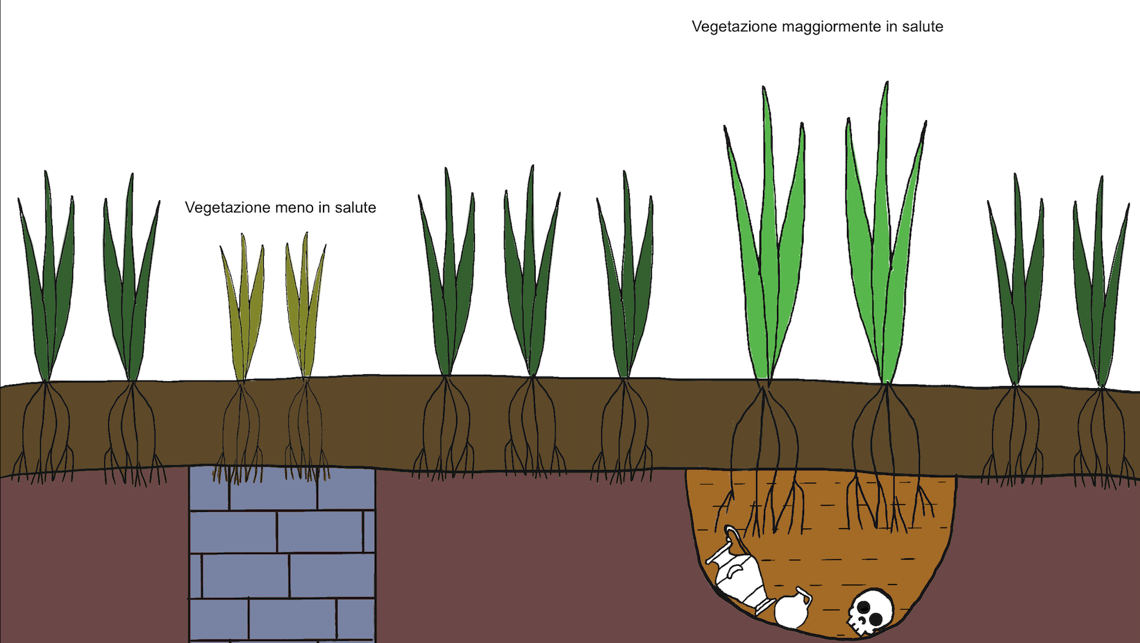
Fig 1: reconstruction of the different health conditions of plants growing over various archaeological elements.
This methodology has its origins in the 1970s when John Hampton, director of the Air Photographs Unit of the Royal Commission on the Historic Monuments of England, conducted experiments with infrared photographic film to identify archaeological traces (Verhoeven, 2012). During the 1980s, with the introduction of the first civilian satellites for remote sensing, interest in multispectral images grew, although the resolution of the early satellites was limited. In the 1990s, with the increase in image resolution and the improvement of technologies, researchers like Sever began using vegetation indices to process multispectral images for archaeological purposes. In particular, Sever conducted a study on prehistoric roads in the Chaco Canyon region, using indices to identify ancient paths (Sever, Wagner, 1991).
The Drone Revolution and Sensor Miniaturization
With continuous technological progress, multispectral sensors have been miniaturized to the point of being mounted on drones, opening up new possibilities for archaeological research. The main advantage of drones lies in their ability to fly at low altitudes, allowing for extremely detailed images. This has made it possible to use multispectral sensors over vast areas of land at a low cost, improving the effectiveness of investigations compared to satellites or airplanes. The speed with which these investigations can be conducted represents an additional advantage: a drone can cover several tens of hectares in a few hours, and data analysis can take place almost in real-time thanks to dedicated software.
The use of drones has profoundly transformed the way archaeological research is conducted. The multispectral images collected can be processed using vegetation indices (VIs), which are mathematical formulas developed to measure the physiological characteristics of vegetation based on its spectral reflectance. These indices allow the detection of differences imperceptible to the human eye and help identify anomalies in the soil that may be linked to the presence of underground structures (fig.2).

Fig.2: difference in anomalies observed using a sensor capturing in the visible spectrum (left) and a multispectral sensor, using NDVI indices (right).
Vegetation Indices in Archaeology
In archaeology, the use of vegetation indices is fundamental for understanding the physiological differences in vegetation linked to the presence of archaeological elements. Among the most common indices used, the document discusses several key ones:
•NDVI (Normalized Difference Vegetation Index): One of the most widely used indices, it relates the reflectance in the red and near-infrared bands. Healthier plants reflect more in the NIR band and absorb more in the red band. This index is useful for identifying areas of stressed vegetation, though it may not always be the most suitable for archaeological investigations.
•GNDVI (Green Normalized Difference Vegetation Index): Similar to NDVI but more sensitive to chlorophyll concentration, making it more effective in the later phenological stages of crops.
•EVI (Enhanced Vegetation Index): Optimizes reflectance in areas with high biomass, reducing atmospheric background noise. It is particularly useful in areas with abundant vegetation.
•NDRE (Normalized Difference Red Edge): Operates in the Red-Edge band, which is sensitive to changes in chlorophyll. It is useful for monitoring plant health and identifying differences caused by underground elements.
•TCARI/OSAVI: Combines the TCARI index, which measures chlorophyll absorption, with OSAVI, which reduces soil influence. This combination is particularly useful for detecting nutritional stress and chlorosis in plants, often caused by the presence of underground structures.
The use of these indices, combined with the multispectral data collected by drones, allows for the identification of anomalies that could indicate the presence of archaeological elements. The choice of index depends heavily on the type of vegetation and the time of year in which the investigation is conducted (Fig.3). For example, multispectral sensors can be particularly effective at certain stages of the vegetation’s phenological cycle, such as during growth or maturation.
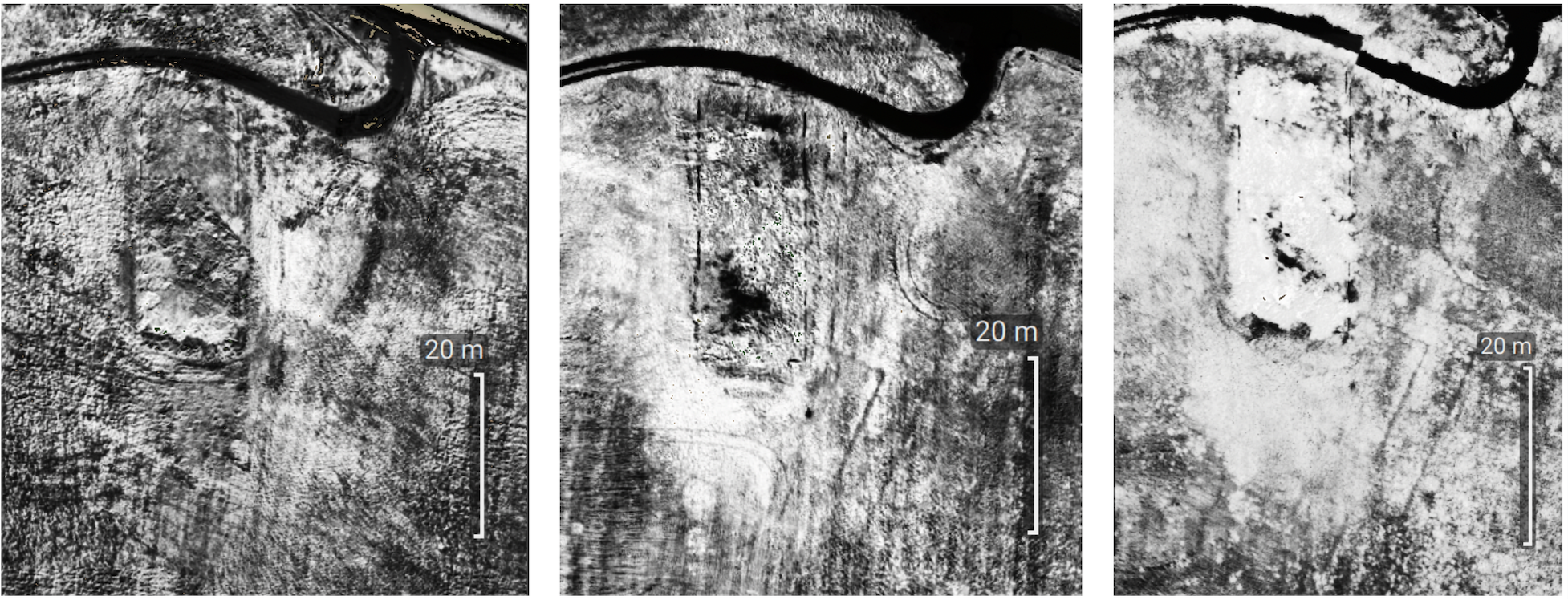
Fig. 3: Detail of the anomaly related to a Roman building in opus reticulatum. From left to right, NDVI vegetation index in October 2020, May 2021, and June 2021.
During the Flying off-siteresearch project, in the Veio site, one of the test areas, the results of multispectral drone flights were compared with aerial images taken over the course of decades and data from magnetometric surveys. The multispectral drone proved effective in detecting a wide range of road and structural traces that had already been identified through other techniques. However, in some cases, multispectral images revealed anomalies that had not been identified by either aerial photography or geophysical surveys, suggesting that multispectral technology can offer added value in archaeology (Ciccone, in press).
The future of multispectral drone archaeology looks very promising. With the improvement of sensor technologies and the integration of increasingly sophisticated data processing software, it is expected that these techniques will be used on a larger scale. Additionally, the combined use of multispectral, thermal sensors, and other non-invasive techniques, such as LIDAR, could lead to an even deeper understanding of the archaeological landscape.
Bibliography:
Abate, N., Frisetti, A., Marazzi, F., Masini, N., and Lasaponara, R. 2021. Multitemporal–Multispectral UAS Surveys for Archaeological Research: The Case Study of San Vincenzo Al Volturno (Molise, Italy). Remote Sensing, 13: 2719.
Agudo, P.U., Pajas, J.A., Pérez-Cabello, F., Redón, J.V., Lebrón, B.E., 2018, The Potential of Drones and Sensors to Enhance Detection of Archaeological Cropmarks: A Comparative Study Between Multi-Spectral and Thermal Imagery. Drones 2018, 2, 29
Ciccone, G., in press, Un’indagine di archeologia aerea a bassa quota sul pianoro di Veio. Un anno di voli con drone multispettrale. Atti del III Convegno di Archeologia Aerea, Le Città invisibili. Remote e Proximal Sensing in Archeologia: Metodologie non invasive per lo studio della città antica. 19-22 Maggio, Lecce.
Fiorini L., Materazzi F., 2017, Un Iseion a Gravisca? Fotogrammetria, telerilevamento multispettrale da APR e dati archeologici per una possibile identificazione. FOLD&R FastiOnLine documents & research (396). pp. 1-23. ISSN 1828-3179
Materazzi, F., and Pacifici, M. 2022. Archaeological crop marks detection through drone multispectral remote sensing and vegetation indices: A new approach tested on the Italian pre-Roman city of Veii. Journal of Archaeological Science: Reports 41.
Sever T.L., Wagner D.W., Analysis of prehistoric roadways in Chaco Canyon using remotely sensed digital data, in Trombold, C.D.,(a cura di), Ancient Road Networks and Settlement Hierarchies in the New World, Cambridge University Press: Cambridge, UK, 1991; 42–52.